")
Satellite Geolocation System
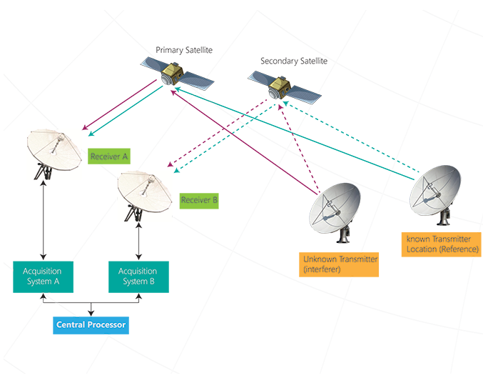
The aim of the satellite geolocation system is to determine the location of an unknown signal source, which sends an interfering signal from the ground to a specific satellite and interferes with the satellite's activity band. These interference signals may be deliberately or due to human error or shortcomings in telecommunication equipment. The shadow of the main signal is received by the secondary satellite in the vicinity of the initial satellite with an angle of less than 4 degrees. The main signal and it’s shadow are relayed by the primary and secondary satellites respectively, to the receiver. In this order, an unknown signal is received and processed by two independent paths. This system focuses on geostationary targets. These satellites have a very small doppler effect as observed at the ground-based station, which can only be detected using correlation techniques.
The aim of the satellite geolocation system is to determine the location of an unknown signal source, which sends an interfering signal from the ground to a specific satellite and interferes with the satellite's activity band. These interference signals may be deliberately or due to human error or shortcomings in telecommunication equipment. The shadow of the main signal is received by the secondary satellite in the vicinity of the initial satellite with an angle of less than 4 degrees. The main signal and it’s shadow are relayed by the primary and secondary satellites respectively, to the receiver. In this order, an unknown signal is received and processed by two independent paths. This system focuses on geostationary targets. These satellites have a very small doppler effect as observed at the ground-based station, which can only be detected using correlation techniques.
Model: KAMAND


Features
• Possibility of positioning for modulated signals and CW
• Positioning Error:
- Modulated Signal: 15 km
- CW Signal: 80 km
• Measurement Accuracy:
- longitude: 0.05
- latitude: 0.1
• Position reports on a High Resolution Map
• Supports different satellite ephemeris formats
• Reprocessing and offline signal evaluation
• Ability to display 72MHz bandwidth spectrum from both satellites around unknown and reference carriers
• Ability to detect shadow signals by SNR down to 25-dB
• Sampling Duration: 33 sec , processing Time ≤ 2 min
Block Diagram
The block diagram of the overall positioning system, along with the diffusion of signals and reference between the ground transmitters, satellite relays and ground receivers, is shown in the figure below.
The block diagram of the overall positioning system, along with the diffusion of signals and reference between the ground transmitters, satellite relays and ground receivers, is shown in the figure below.